
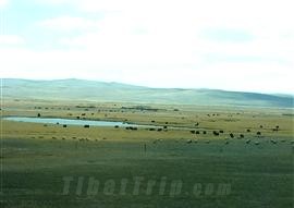
 Amdo County is within the prefecture of {{Nakchu|/nakchu/}} Region, covering an area of about 26 thousand sq km. (6.4 million acres). At an average altitude of over 4,700 m. (15,120 ft.), it is occupied by some high mountains, forming a ridge shaped physiognomy. The county is mainly a pastoral area, which accounts for over half of Qiangtang Grassland, the largest grassland of Tibet. Besides, there are also many lakes and rivers dotted within the county.
The famous attractions in Amdo include the show capped Tanggula Mountain, its main peak - Geladandong Peak, with amazing icy pagodas and icy palaces, and Cuona Lake, which can all be seen from the Tibet train. In addition, the distinctive local houses and folk customs are also worth seeing.
Amdo County is within the prefecture of {{Nakchu|/nakchu/}} Region, covering an area of about 26 thousand sq km. (6.4 million acres). At an average altitude of over 4,700 m. (15,120 ft.), it is occupied by some high mountains, forming a ridge shaped physiognomy. The county is mainly a pastoral area, which accounts for over half of Qiangtang Grassland, the largest grassland of Tibet. Besides, there are also many lakes and rivers dotted within the county.
The famous attractions in Amdo include the show capped Tanggula Mountain, its main peak - Geladandong Peak, with amazing icy pagodas and icy palaces, and Cuona Lake, which can all be seen from the Tibet train. In addition, the distinctive local houses and folk customs are also worth seeing.Transportation in the county is very convenient. The Anshi Highway (Amdo-Shiquanhe) traverses the whole county, affording easy access to most towns of the region.
![]() Related Link: Map of the Tibet Railway Scenery
Related Link: Map of the Tibet Railway Scenery