
 At an altitude of 5,231 m (17,162 ft), the pass is the highest point of Qinghai-Tibet Highway, while the railway is at its highest point of 5,072 m (16,640 ft). The oxygen content is only 60% of that in the plains. Although the weather here frequently changes, the area can be icy resulting in dangerous road conditions. The railway station is the highest one in the world which is why there is oxygen access in the waiting room. It has no watch but with a viewing platform, the spot is the best point to see the Tanggula Mountain.
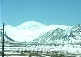
Tanggula Mountain literally means 'mountain on the plateau' in Tibetan and 'high mountain insurmountable by eagles' in Mongolian. It is connected by the Karakoram Mountains to the west and the Hengluan Mountains to the east, extending about 1000 km (621 mi) long and 150 km (93 mi) wide. The mountain is the watershed of the Yangtze and the Nu Rivers, and the seedbed of these two rivers and Lancang River. The source of Yangtze River – Tuotuo River just originates from its main peak, Geladandong Peak. Generally at the altitude of 5,000 – 6,000 m (16,404 – 19,685 ft), the mountain is capped with snow all the year round, with dozens of ancient glaciers racing down the side – a spectacular view.
![]() Back to Map of the Tibet Railway Scenery
Back to Map of the Tibet Railway Scenery