 Situated about 90 kilometers (55.9 miles) northwest to Lhasa City, the Yangpachen geothermal area has many hot water wells and hot springs, which covers an area of 40 square kilometers (15 sq miles). Its grass is green all year-round; even during bitter winter when the temperature is usually -20 C, its hot spring water is still 30 - 40 C.
By using its rich natural resources, Yangpachen has the largest geothermal energy power station in China, whose yearly output supplies 45% of electricity required by Lhasa City. The hot spring resort is in the open air, which attracts both residents of Lhasa and tourists alike.
Tip: Due to its high altitude, spending too long time to take a bath in hot springs is not recommended, because of the possibility of oxygen-deficient environment.
Situated about 90 kilometers (55.9 miles) northwest to Lhasa City, the Yangpachen geothermal area has many hot water wells and hot springs, which covers an area of 40 square kilometers (15 sq miles). Its grass is green all year-round; even during bitter winter when the temperature is usually -20 C, its hot spring water is still 30 - 40 C.
By using its rich natural resources, Yangpachen has the largest geothermal energy power station in China, whose yearly output supplies 45% of electricity required by Lhasa City. The hot spring resort is in the open air, which attracts both residents of Lhasa and tourists alike.
Tip: Due to its high altitude, spending too long time to take a bath in hot springs is not recommended, because of the possibility of oxygen-deficient environment.
Like Us on: 
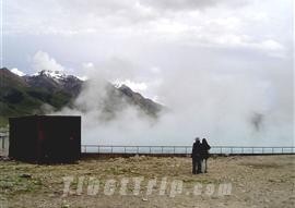
Yangpachen
Yangpachen is an electricity town built around a thermal power plant 87 kilometers(54 miles) north of Lhasa, halfway to Damxung.
Lying about 4, 300 meters (14, 000 ft) above sea level, Yangpachen has a unique natural phenomenon: warm, green grassland valley encircled by snow-caped mountains of over 5,500 meters (18, 000 ft) in height.
Situated about 90 kilometers (55.9 miles) northwest to Lhasa City, the Yangpachen geothermal area has many hot water wells and hot springs, which covers an area of 40 square kilometers (15 sq miles). Its grass is green all year-round; even during bitter winter when the temperature is usually -20 C, its hot spring water is still 30 - 40 C.
By using its rich natural resources, Yangpachen has the largest geothermal energy power station in China, whose yearly output supplies 45% of electricity required by Lhasa City. The hot spring resort is in the open air, which attracts both residents of Lhasa and tourists alike.
Tip: Due to its high altitude, spending too long time to take a bath in hot springs is not recommended, because of the possibility of oxygen-deficient environment.
Comments and Questions
Dear Sir:
Is it true that the Yangpachen field lies inside the Yangbajing district?
9/18/2010 4:21:00 PM
|Yangpachen is also named Yangbajing, and it is located in the Dangxiong County.
9/18/2010 7:50:00 PM
|Sera